Mixed-Use Neighborhood Planning: Trends and Design Principles

What if homes, shops, and public spaces are close together but daily trips still feel awkward? That is the practical challenge of mixed-use neighborhood planning. Proximity is only a starting point: streets, routes, access points, and transitions between uses all affect how well a neighborhood works.
A neighborhood can include housing, services, and open space yet leave residents with indirect routes or uncomfortable edges between busy and quiet areas. The planning task is to make each part support the others.
This article explains common mixed-use patterns and the decisions that shape connected daily life, from route planning and shared spaces to the fit between residential and commercial uses. It also considers how planning can respond to a specific place, informed by Mark Tanney’s Traditional Neighborhood Development background, including work in Tapestry Park and Rosemary Beach.
Table of Contents
What Mixed-Use Neighborhood Planning Combines, and What It Does Not
Mixed-use neighborhood planning coordinates complementary uses, such as homes, shops, services, and public spaces, across a shared neighborhood. The goal is to plan how these elements relate, not simply to place them within the same boundary.
A neighborhood plan differs from a single-building mixed-use development. It organizes relationships among uses, routes, and shared spaces across an area, while a single-building project combines uses within one structure. Homes near a shop may look mixed-use on a plan, but proximity alone does not guarantee a convenient route, clear access, or a connected public realm.
Mixed-use development combines residential, commercial, and other functions within an area, with potential for pedestrian connections. At the neighborhood scale, the key question is how those functions connect in practice. A service across a busy road, for example, may be close on a map but difficult to reach on foot.
Horizontal and Vertical Mixed-Use Patterns
Horizontal mixing places different uses in neighboring buildings or blocks. Vertical mixing combines uses within one building, such as shops at street level and homes above. Neither pattern is automatically better. Each calls for a different review of entrances, transitions, and connections to surrounding streets and spaces.
The two patterns can also work together. Reviewing both helps establish whether the mix makes sense at the building scale and remains connected across the wider neighborhood.
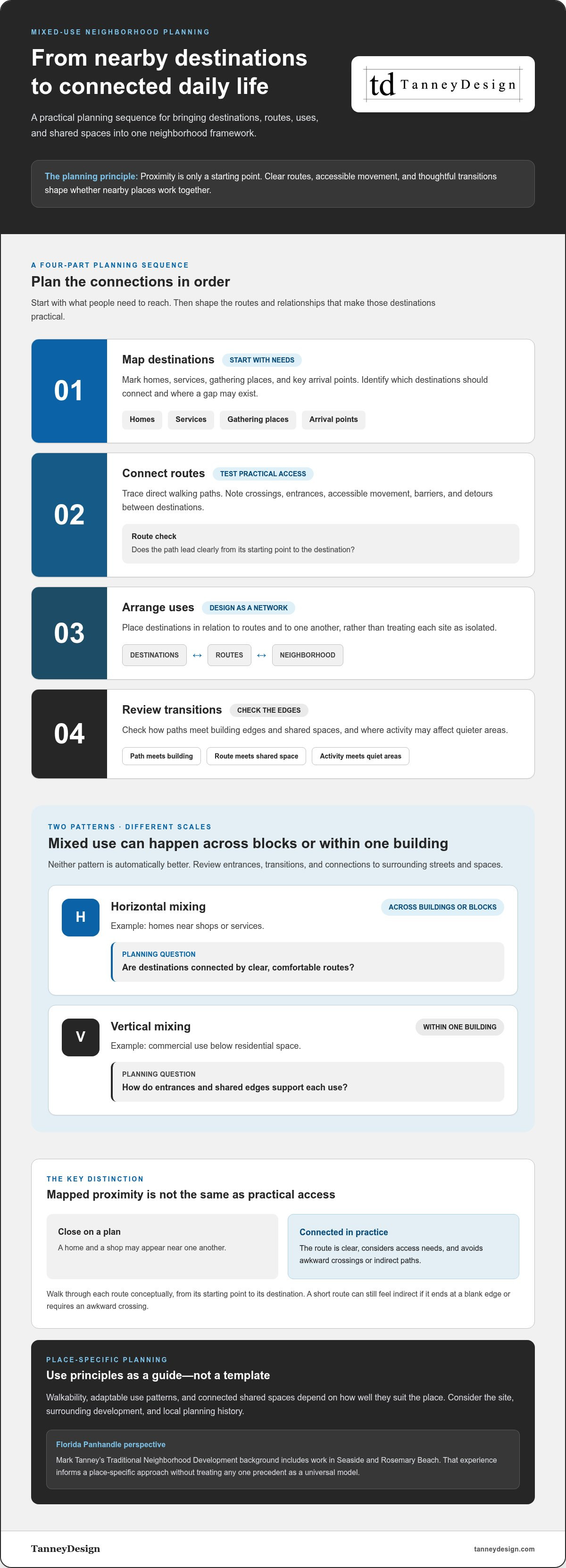
How Mixed-Use Neighborhood Planning Connects Uses, Routes, and Shared Spaces
Start with destinations, not building types. A practical sequence is to map everyday destinations, connect routes, arrange uses, and then review transitions and shared spaces. A grocery, community room, or transit stop is useful to nearby residents only if routes lead to it clearly and account for different access needs.
Map destinations. Mark homes, services, gathering places, and key arrival points. This shows which destinations should connect and where a gap may exist.
Connect routes. Trace direct walking paths and note crossings, entrances, and accessible movement. Look for barriers or detours between destinations.
Arrange uses. Place destinations in relation to the routes and to one another, rather than treating each site as isolated.
Review transitions. Check how paths meet building edges and shared spaces, and where activity may affect quieter areas.
A route can be short yet feel indirect if it ends at a blank edge or requires an awkward crossing. Walk through the plan conceptually, following each route from its starting point to its destination. This can reveal the difference between mapped proximity and practical access. A useful mix of uses depends on planning destinations and routes together.
Balancing Daily Activity with Neighborhood Coherence
Shared areas can bring daily activity, while nearby residential spaces may need a quieter character. Entrances, route alignments, and gathering-space locations help shape the transition. Their effect depends on the site and the way the plan responds to it. The broader relationship between site layout and community structure is also explored in “Residential Neighborhood Planning: From Site to Community.”
In a place-specific plan, neighborhood planning can bring layout, movement, and shared space into one framework.
Mixed-Use Planning Trends and a Florida Panhandle Perspective
Walkability, adaptable use patterns, and connected shared spaces remain important themes in mixed-use planning. They are not automatic benefits of combining uses. Review whether routes connect destinations clearly, whether shared spaces fit their surroundings, and whether buildings can support changing needs over time.
Local context shapes those decisions. For projects in Panama City Beach, Inlet Beach, Santa Rosa Beach, Grayton Beach, Destin, and Panama City, consider the site, its surrounding development, and the area’s planning history rather than applying one pattern everywhere. A layout suited to an established town may not translate directly to another setting. The task is to identify what should connect, where transitions matter, and how new development can relate to its context.
Applying Traditional Neighborhood Development Experience
Mark Tanney’s Traditional Neighborhood Development background includes foundational work in the Florida Panhandle at renowned regional projects like Seaside and Rosemary Beach. That experience informs TanneyDesign’s neighborhood-planning work and offers a grounded perspective on how layout and shared spaces relate to a specific place, without treating any one precedent as a template.
TanneyDesign’s neighborhood-planning work applies planning principles with attention to the character and needs of each site.
Shape a Neighborhood Around Its Next Chapter
Every site presents different relationships to consider. Identify what residents need nearby, how the place can connect to its surroundings, and where its character should remain distinct. That local perspective is central to thoughtful mixed-use neighborhood planning.
TanneyDesign has operated since 1995. Founder Mark Tanney brings experience in Traditional Neighborhood Development contexts in the Florida Panhandle, grounding planning decisions in design principles and regional experience.
To discuss a neighborhood planning project, get in touch with TanneyDesign and start with a clear, place-specific framework for shaping the neighborhood’s future.
Frequently Asked Questions
What is mixed-use neighborhood planning?
Mixed-use neighborhood planning coordinates homes, services, and shared destinations so their placement supports daily activity across a neighborhood. A plan might consider how homes relate to a local service cluster, community spaces, and arrival points. The measure is not simply whether different uses are present, but whether the overall layout works for the people who will use it.
What is the difference between horizontal and vertical mixed-use development?
Horizontal mixed-use development places different uses in separate buildings or areas, while vertical mixed-use development combines uses within one building. A horizontal arrangement might place housing beside a small commercial building; a vertical one might put shops below homes. The choice depends on the site, the intended relationships between uses, and how each arrangement fits its surroundings.
Does mixed-use planning make a neighborhood walkable?
No. A mix of destinations can support walking, but the layout and route experience matter too. A nearby park may be difficult to reach if the route is indirect or an entrance is poorly positioned. Reviewing crossings, access for people with different mobility needs, shade, and the relationship between paths and destinations helps show whether walking is a practical option.
How does mixed-use planning relate to Traditional Neighborhood Development?
Traditional Neighborhood Development (TND) is a planning approach that considers how buildings, streets, and public spaces form a connected neighborhood. Mixed uses may be part of that approach, but the terms are not interchangeable: mixed-use describes the presence of different uses, while TND addresses a broader pattern of neighborhood organization. In Panama City Beach, Inlet Beach, Santa Rosa Beach, Grayton Beach, Destin, and Panama City, local context informs how that pattern is applied.

Comments